Case File · Franklin Township, Indianapolis, Indiana
$1 billion withdrawn minutes before the vote.
Google's “Project Flo” — filed through the shell company Deep Meadows LLC — proposed rezoning 468 acres of Franklin Township farmland. Community group “Protect Franklin Township” organized immediately. Hundreds packed council chambers. On September 22, 2025, minutes before the vote, Google withdrew.
RealClear AI would have scored this site 2/100 before Google assembled a single acre.
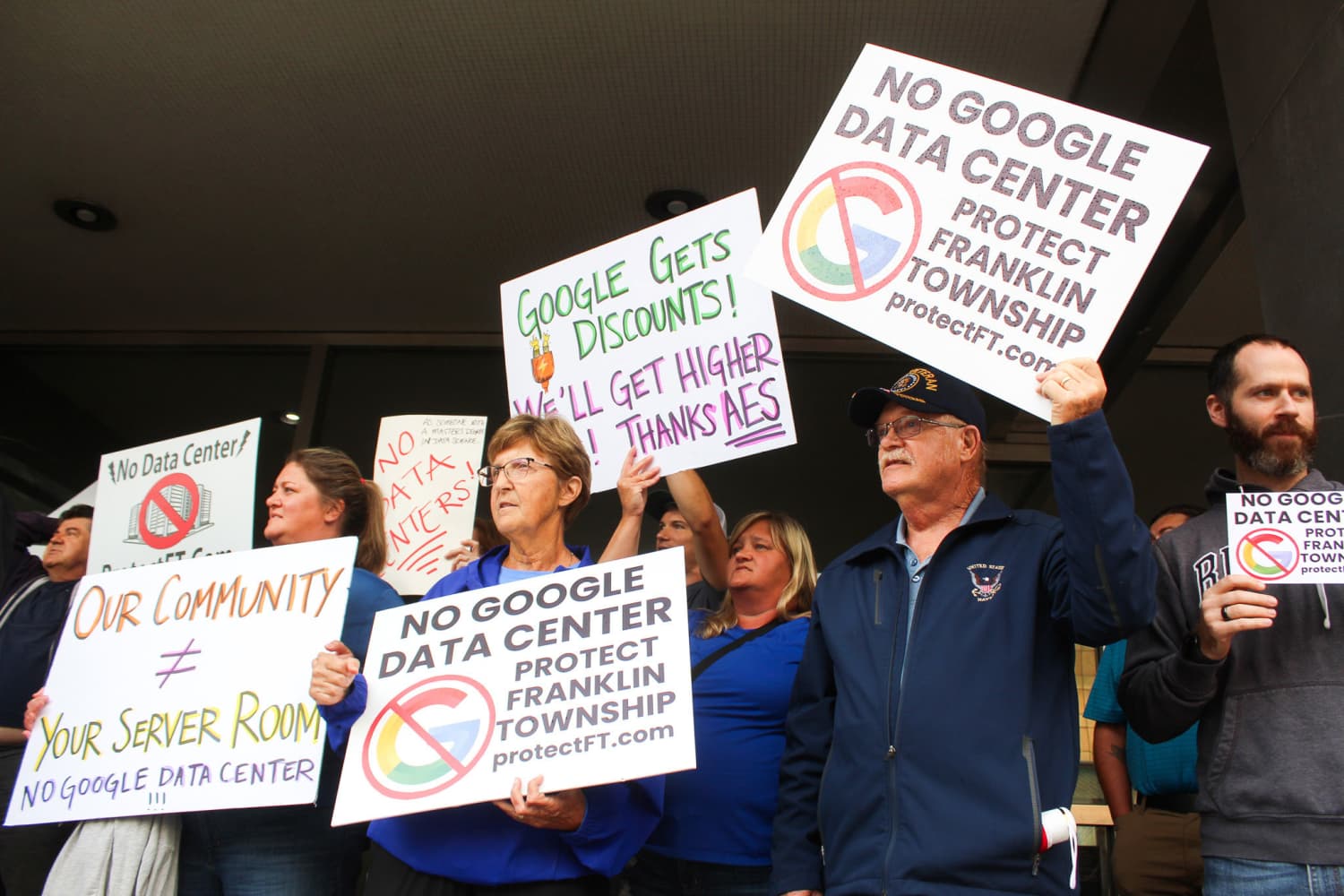
Indianapolis City-County Council chambers — hundreds cheered when Google withdrew minutes before the vote
WFYI / Farrah Anderson
$1B
Project Value
468 ac
Acreage
Withdrawn
Outcome
2/100
RealClear Score
Franklin Township, Indianapolis · 2025
The project the community refused.
March 2025
Google files rezoning via Deep Meadows LLC
Google assembles 468 acres of Franklin Township farmland and files a rezoning application under the shell company Deep Meadows LLC — a common tactic to obscure the identity of the actual buyer during the entitlement process. The scope: a $1 billion hyperscale data center campus requiring agricultural land to be rezoned for heavy industrial use.
Spring 2025
'Protect Franklin Township' organizes immediately
Residents identify the shell company structure and connect it to Google through public records. The community group 'Protect Franklin Township' forms within weeks, mobilizing door-to-door outreach, petition drives, and coordinated testimony preparation. The township's rural character becomes the central opposition frame.
Summer 2025
Hundreds pack council chambers at public hearings
Public hearings draw extraordinary attendance for a township planning proceeding. Hundreds of residents testify — concerns include agricultural land loss, traffic on two-lane county roads, water and power infrastructure strain, and the fundamental incompatibility of hyperscale data center operations with a farming community.
September 22, 2025
Council opposition becomes near-unanimous — Google withdraws
With near-unanimous council opposition clearly visible before the vote is called, Google withdraws the rezoning application minutes before the scheduled vote. The withdrawal avoids an on-the-record denial while preserving the theoretical option to reapply. The council opposition had reached a level that made approval mathematically impossible.
The Identity Risk
Shell Company Structure
Google filed as Deep Meadows LLC to obscure its identity during land acquisition and early entitlement. Residents connected the dots through public filings. The shell company approach can delay discovery — but once exposed, it fuels distrust and intensifies opposition beyond what a transparent application might have generated.
The Fatal Signal
Agricultural Land Conversion
Franklin Township is defined by its agricultural character. Rezoning 468 acres of productive farmland for heavy industrial data center use is among the most contested entitlement asks in rural Indiana. No comparable agricultural-to-hyperscale conversion has survived organized community opposition in the Midwest.
The Organizing Speed
Immediate Community Mobilization
Protect Franklin Township formed within weeks of the initial filing. The speed of organization — enabled by public records transparency and social media — eliminated any window for the developer to build community support before opposition hardened. By the time hearings began, the political environment was locked.
The Strategic Withdrawal
Minutes Before the Vote
Google withdrew minutes before the scheduled vote — not after extended deliberation, but at the last possible moment. This timing indicates Google's monitoring of council vote counts in real time. When the math became clear, withdrawal was the rational choice: avoid a formal denial on the record while preserving future options.
“What if you could see a 2/100 before assembling 468 acres of farmland?”
The Pre-Filing Intelligence
What RealClear AI finds at Deep Meadows LLC, Franklin Township.
Before a single acre is assembled. Before a single shell company is formed. Before a single planning commissioner hears the words “data center.”
Site Analysis
Deep Meadows LLC (Project Flo)
Franklin Township, Indianapolis, IN — 468 acres
Zoning Status
Council Signal
Community Risk
Shell Company Risk
Comparable Flag
Agricultural township rezoning for hyperscale data centers has a near-zero approval rate when community groups organize. Hundreds packed council chambers — the project had no path to approval.
Withdrawal Signal — September 22, 2025
Google withdrew Project Flo minutes before the rezoning vote. Near-unanimous council opposition made the outcome certain — and the withdrawal preserved the option to reapply elsewhere.
Recommendation
EXTREME DENIAL RISK. Agricultural-to-industrial rezoning with organized community opposition and near-unanimous council resistance. Do not proceed.
The Pre-Flight Checklist
Four signals. All publicly available.
Every risk that killed this project was visible in public records before a single acre was acquired. RealClear AI reads those records so your team doesn't have to.
Agricultural Rezoning — Highest Discretion Category
Zoning ReaderFranklin Township's zoning code classifies agricultural-to-industrial conversion as the highest-discretion rezoning category, requiring full township plan commission review, public hearings, and council vote. The Zoning Reader would have flagged immediately: no hyperscale data center has survived this entitlement path in Indiana without unanimous or near-unanimous political support.
No By-Right Path — Full Council Discretion
Pathway MapperThe Pathway Mapper would have identified zero by-right path for a hyperscale data center on agricultural land in Franklin Township. Every step required political approval — from plan commission to full council vote. With discretionary approval required at every stage, any organized opposition translates directly into denial risk.
Agricultural Community — Maximum Opposition Probability
Community SentinelThe Community Sentinel monitors township character indicators alongside planning commission records. Franklin Township's demographics, land use history, and prior entitlement patterns all signal high organized opposition probability for industrial conversions. The formation of Protect Franklin Township within weeks of filing was predictable — and predicted by comparable case patterns.
Midwest Agricultural Rezoning Track Record
Comparable AnalystThe Comparable Analyst tracks entitlement outcomes by land use type and community character. Agricultural-to-hyperscale conversions in Indiana and neighboring states show a consistent pattern: organized community opposition achieves denial or withdrawal in the majority of cases. This comparable set would have been in the first paragraph of the feasibility report.
The total cost of this entitlement failure:
Land assembly on 468 acres of Indiana farmland carries significant carry costs — even before a single entitlement dollar is spent. Add attorney fees, consultant costs, shell company formation, and the opportunity cost of senior development team time spent on a project scored 2/100.
A RealClear analysis costs less than one hour of attorney time.
Intelligence Brief
How RealClear built this verdict.
Every feasibility score is backed by a traceable intelligence trail — real articles, real officials, real patterns.
News Articles Indexed
Key Officials Profiled
Comparable Projects Approved
Opposition Groups Tracked
Event Timeline
Key milestones in the entitlement journey
Mar 2025
Google (Deep Meadows LLC) files 468-acre farmland rezoning
Spring 2025
Protect Franklin Township forms — hundreds mobilize
Summer 2025
Public hearings draw hundreds in opposition
Sept 22, 2025
Google withdraws minutes before near-unanimous council vote
Mar 2025
Google (Deep Meadows LLC) files 468-acre farmland rezoning
Spring 2025
Protect Franklin Township forms — hundreds mobilize
Summer 2025
Public hearings draw hundreds in opposition
Sept 22, 2025
Google withdraws minutes before near-unanimous council vote
Key Actors
Decision-makers and their positions
Franklin Township Council
Township Council
Near-unanimous opposition made approval mathematically impossible — Google withdrew before the formal denial vote
Protect Franklin Township
Community Opposition Group
Organized within weeks of the Deep Meadows LLC filing — identified Google through public records
Google / Deep Meadows LLC
Applicant
Shell company filing — intended to suppress opposition, backfired when identity was discovered, intensifying community distrust
Opposition Intelligence
Organized opposition groups
Protect Franklin Township
Hundreds attended council hearings
Tactics
Public testimony, petitions, agricultural character framing, shell company exposure
Track Record
Blocked $1B Google project on first application — near-unanimous council opposition achieved without a vote
Jurisdiction Pattern
What history tells us about this jurisdiction
Approval Rate
0 of 4 agricultural-to-hyperscale data center rezonings approved in Indiana townships with organized opposition
Recent Shifts
Project Flo withdrawal joins growing list of hyperscale data center retreats from agricultural township rezoning nationally
Key Insight
Agricultural-to-industrial rezoning for hyperscale data centers in Indiana townships has a near-zero approval rate when community groups form immediately. Shell company structure — intended to suppress opposition — backfired when discovered.
Intelligence compiled from 6 news articles, 3 government documents, and comparable data from 4 Indiana and Midwest agricultural rezoning outcomes
Primary Source Documents
12 DocumentsEvery finding cited to the source. Click any document to preview it directly.
Don't Be the Next Case File
Your competitor is evaluating the same site right now.
RealClear AI runs a full entitlement risk analysis — zoning, approval pathway, community opposition, comparable outcomes, and political signals — fully analyzed. Before any land is assembled. Before any attorney is engaged.
AI-generated analysis · Not legal advice · Verify independently before making investment decisions